KUNOVICE AIRPORT

  • arrow International Airport Code ICAO/IATA: LKKU/UHE
  • arrow Aerodrome coordinates: N49°01'46" E017°26'23"
  • arrow Type of operation: IFR, VFR
  • arrow Owner and operator Aircraft Industries, a. s.
  • arrow Physical characteristics of airport runways:
  • 02C/ 20C 2000 x 30 m, concrete surface, load capacity PCN 33/R/B/X/T
  • 02L/ 20R 1315 x 40 m, grass surface, load capacity 25.000 kg
  • 02R/ 20L 1315 x 40 m, grass surface, load capacity 25.000 kg
  • arrow Elevation 581 ft/177 m
  • arrow Instrument approach procedure NDB, RNAV RWY 20C
  • arrow TWR / AFIS frequency 120.105 MHz
  • arrow Hours of operation Monday - Friday, from 08:00 till 16:00 LT or upon request 24 hours.

  • SERVICES

  • arrow Commercial air transport (unscheduled, international, national)
  • arrow Aerial work
  • arrow Test flights
  • arrow Operation of gliders and baloons
  • arrow Recreational and sport flights
  • arrow Training flights


  • Office

    +420 572 817 610
    pavel.stasek@let.cz

    Tower, Briefing

    +420 572 817 620
    +420 572 817 621
    twrlkku@let.cz

    Meteo

    +420 572 817 630
    meteo@let.cz

    Handling

    +420 572 817 640
    +420 606 094 670
    handling@let.cz


    UNMANNED AIRCRAFT

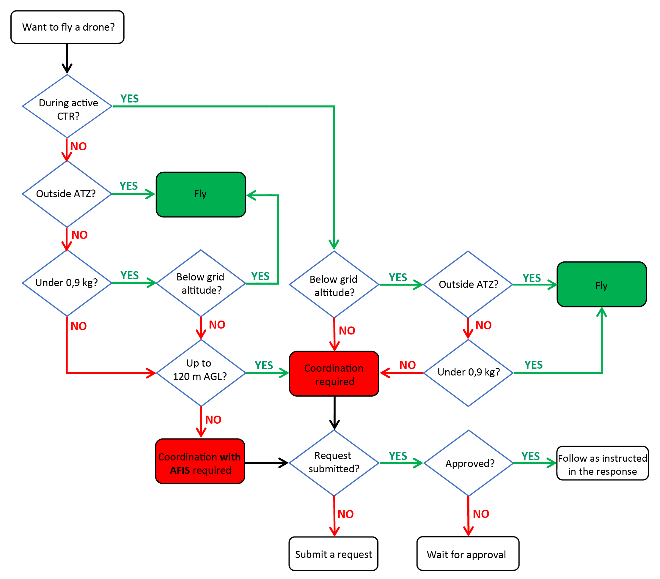
    The requirement to coordinate unmanned aircraft (drone) operations within a CTR or ATZ depends on their geographic location, maximum altitude, and weight.

    If in doubt, please follow the decision diagram below:

    diagram

    You can find the grid map for LKKU here, or on the website dronview.rlp.cz.

    For flights requiring coordination, a written request is necessary. You may use our online form, or send your request to twrlkku@let.cz. If AFIS is required, please contact handling@let.cz. Further information can be found in the Aerodrome Regulations, Chapter 9.

    Please note: Coordination by phone is only used for activities that have already been preliminarily approved.

    Online form – for flights requiring coordination